Music is set to start automatically. If your browser blocks autoplay, click Music On once.
Site Navigation

Cave Dive World · country catalogue

Namibia

Dragon’s Breath · Harasib · Guinas · Otjikoto · Aigamas · Otavi karst · deep CCR · rope access · robotics · rescue · cave biology.

Cave Dive World banner

integrated research · v0.1

Namibia — research catalogue integrated

Namibia combines deep inland groundwater caves, open collapse sinkholes, vertical rope-access expeditions, extreme CCR/mixed-gas diving, robotic mapping and uniquely fragile cave biology.

Two distinctions are non-negotiable: robot-mapped depth is not human dive depth, and the blind cave catfish belongs to Aigamas — not Dragon’s Breath.

Namibia · research catalogue

National priority cave and overhead catalogue

Dragon’s Breath Cave / Drachenhauchloch

Region: Harasib Farm / Otjozondjupa

Type: UNDERGROUND LAKE / FULL CAVE

Published scale: Lake ~60 m below ground; ~205 m water depth by 2019 AUV; cave datum ~264 m

Status: PRIVATE / PROFESSIONAL EXPEDITION

KCore note: World’s largest known non-subglacial underground lake by surface area; major 2019 robotic and 2024 human projects.

Harasib Cave

Region: Harasib Farm / near Tsumeb

Type: VERTICAL SHAFT + DEEP FLOODED CAVE

Published scale: Water >110 m below entrance; ~162 m human dive in 2016; later ~179 m reported; AUV bottom ~265 m underwater

Status: PRIVATE / EXTREME EXPEDITION

KCore note: One of Namibia’s hardest access sites; enormous deep chamber mapped by SUNFISH.

Lake Guinas

Region: Oshikoto / west of Tsumeb

Type: OPEN COLLAPSE SINKHOLE + CAVERNS

Published scale: ~130–153 m class; historic ~132 m dive in 1989

Status: PRIVATE / CONCESSION / TECHNICAL

KCore note: Open sky above but bell-out walls and caverns below; endemic Tilapia guinasana.

Lake Otjikoto

Region: Oshikoto / near Tsumeb

Type: OPEN COLLAPSE SINKHOLE + SIDE CAVES

Published scale: ~75–100 m commonly published; deeper side-cave claims

Status: NATIONAL HERITAGE / PERMIT

KCore note: Underwater WWI museum and classic Southern African cave-diving site.

Aigamas Cave

Region: Otavi area / Otjozondjupa

Type: SUBTERRANEAN CAVE LAKE / BIOLOGY

Published scale: Dives >90 m reported; research surveys to 40 m; additional pools ~87 m below surface

Status: PRIVATE / RESEARCH / CONSERVATION

KCore note: Only confirmed natural home of the Critically Endangered blind cave catfish Clarias cavernicola.

Ghaub Cave lake

Region: Otavi Mountain Land

Type: DRY SHOW CAVE + SUBTERRANEAN WATER

Published scale: ~2.5 km cave; ~38 m vertical depth; internal lake

Status: TOURISM / SCIENCE / HYDROLOGY

KCore note: Important groundwater context, but not a routine public scuba cave.
Namibia · research catalogue

National KCore identity — cave diving in a desert groundwater reservoir

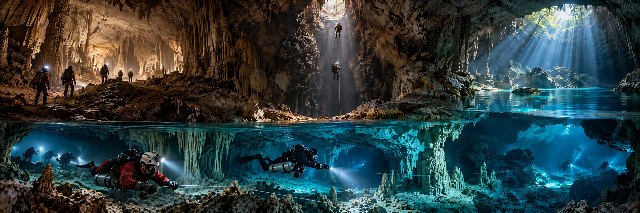
Namibia’s flooded caves cluster in the Otavi Mountain Land around Tsumeb, Otavi and Grootfontein, where ancient carbonate terrain hides enormous groundwater caverns. Some have collapsed to open sinkholes; others remain underground behind deep shafts.

Altitude, deep mixed-gas diving, rope access, private-farm logistics, groundwater science and fragile endemic biology all belong in the core site data. These are not details to add after the dive plan.

Namibia · research catalogue

Dragon’s Breath — the hidden lake beneath the desert

Dragon’s Breath was discovered during South African speleological exploration in 1986. Constricted dry passage and vertical drops lead to a giant underground lake whose surface lies roughly 60 m below ground and covers almost two hectares.

In 2019 Stone Aerospace’s SUNFISH autonomous vehicle mapped about 205 m of water depth and a cave datum around 264 m below the entrance. The huge chamber can make a fully enclosed cave feel paradoxically like blue-water technical diving because walls and ceiling may disappear from view.

The 2024 Scapehander expedition hauled roughly 1.5–1.8 tonnes of equipment into the cave, installed floating platforms and conducted multi-CCR dives. Public sources disagree on the exact human maximum, with mid-150 m figures and later wording around 200 m. KCore preserves that discrepancy until the primary expedition log is available.

Namibia · research catalogue

Harasib — more than 100 metres of rope before the dive begins

Harasib’s water lies more than 110 m below the entrance. Every rebreather, cylinder, battery and diver must be lowered into the shaft and later hauled out, making vertical-cave logistics inseparable from the underwater plan.

Cobus Briel and Almero Retief reached approximately 162 m in 2016 using helium and rebreathers; later Scapehander reporting gives around 179 m. The 2019 SUNFISH project then mapped an apparent bottom around 265 m underwater and revealed a giant previously unknown chamber.

This is one of Cave Dive World’s clearest examples of robotics extending the map beyond routine human range rather than replacing divers.

Namibia · research catalogue

Lake Guinas — open sky above, cave geometry below

Guinas is a collapsed dolomite sinkhole with an open surface pool, but the walls bell outward and side cavern geometry creates genuine overhead below. Published depth varies by source and water level, roughly 130–153 m.

Boetie Scheun and Eben Benade reportedly reached about 132 m in 1989. In September 2024 a 16-year-old school visitor drowned recreationally; this was not a cave-diving accident. Ordinary police divers could not work at the required depth, and specialist technical divers recovered the body in January 2025 from more than 100 m.

That distinction matters: a surface-water drowning can become an extreme technical recovery when a body descends into deep karst geometry.

Namibia · research catalogue

Otjikoto — underwater war museum and permit-controlled sinkhole

Otjikoto formed by collapse of a large karst cavern and became historically famous when retreating German colonial forces dumped artillery and other military equipment into the lake in 1915.

The site is a national heritage environment with permit control. Published depth figures vary, and side-cave claims should be separated from the open central water column. Heritage objects remain protected material, not dive souvenirs.

Namibia · research catalogue

Aigamas — the cave where biology matters more than depth

Aigamas is the only confirmed natural habitat of the blind cave catfish Clarias cavernicola. Research diving in 2019 surveyed the principal pool and additional cave pools; scientists dived to 40 m, but the fish were observed only to about 17 m.

The species depends strongly on shallow feeding ledges linked to the bat-supported cave food web. Groundwater abstraction has lowered the water table by roughly 20 m historically, threatening that habitat.

A persistent internet error places this catfish in Dragon’s Breath. KCore explicitly rejects that: the confirmed natural distribution is Aigamas.

Namibia · research catalogue

Altitude and rope work — the cave diver must also be a vertical caver

Major Namibian cave sites lie roughly 1,250–1,550 m above sea level, so decompression exposure begins at reduced surface pressure before the dive depth is added.

Dragon’s Breath and especially Harasib make SRT, hauling and rope rescue part of cave-diving competence. An injured diver still has to be moved vertically to daylight after a long technical dive.

Namibia · research catalogue

Training culture — low visibility at home, extreme caves on expedition

Most Namibian divers live far from the Otavi caves. Technical skill development often takes place in dams near Windhoek, where silt and poor visibility create demanding stage, search and team-awareness training.

Current Namibian technical operators support CCR, trimix and cave expeditions, but Dragon’s Breath and Harasib remain private expedition objectives rather than routine course classrooms.

Namibia · research catalogue

People, teams and organisations

Roger Ellis and Charles Maxwell — early Dragon’s Breath discovery and diving generation.
Boetie Scheun and Eben Benade — historic deep Guinas dives.
Nuno Gomes and Don Shirley — Southern African deep-cave expedition culture.
Cobus Briel and Almero Retief — 2016 Harasib deep dive.
Bill Stone / Stone Aerospace and the SUNFISH team — 2019 autonomous 3D mapping.
Chris Steenkamp, Tom Baier and Scapehander — modern Namibian/German expedition and recovery work.
Dantica Diving / Windhoek technical community — current technical support and training ecosystem.

Namibia · research catalogue

Rescue, recovery and public-safety context

The 2024–25 Guinas recovery exposed the gap between ordinary public-safety dive limits and a 130 m-plus karst lake. It supports the case for pre-planned cooperation between police, civilian technical divers, ROV teams and decompression support.

Harasib and Dragon’s Breath have no major public human cave-diving fatality strongly documented in this research pass, but their rescue problem is dominated by depth, rope access and remoteness. Absence of a famous accident does not mean low risk.

Namibia · research catalogue

Robotics, geology, groundwater and paleobiology

The 2019 SUNFISH survey combined laser mapping above water with multibeam sonar and autonomous navigation underwater. Dragon’s Breath, Harasib and Guinas became some of the best examples of robotic cave mapping integrated with human exploration.

The Otavi Mountain Land is a regional groundwater system, but hydrological relationship does not equal human-passable cave connection. Guinas, Otjikoto, Ghaub and other caves may share aquifer behavior without being dive-connected.

Namibia also preserves paleocaves and endemic aquatic fauna, making conservation and groundwater abstraction central to the cave-diving story.

Namibia · research catalogue

Artificial overhead — search carefully, do not invent a mine scene

Namibia is a mining country and occupational regulations address commercial underwater work, but this research did not verify an established recreational flooded-underground-mine penetration culture.

Open pits and quarry water remain open water unless submerged galleries are proven. Otjikoto’s WWI artefacts add a heritage layer to a natural sinkhole; they do not make the cave artificial overhead.

Namibia · research catalogue

Conservation and access

Dragon’s Breath and Harasib are private professional-expedition sites. Guinas is private/concession-controlled and biologically important. Otjikoto is permit-controlled heritage. Aigamas is conservation-first because of its Critically Endangered cavefish.

Historical expedition reports never establish current access. Farm owners, permits, endangered species and groundwater management are part of legitimate publication and project planning.

Namibia · research catalogue

Discovery frontiers — divers and robots together

Dragon’s Breath: SUNFISH mapped the apparent bottom, while human exploration covers only part of the huge volume.
Harasib: the robot revealed a deep chamber beyond current routine human depth and rope logistics.
Guinas: modern 3D data may refine side-cavern geometry that shot-line dives barely saw.
Otjikoto: side-cave claims need modern cave-specific survey.
Aigamas: additional pools remain a conservation and habitat frontier.
Otavi aquifer: regional groundwater links may connect systems hydrologically even when no human-passable cave exists.

Namibia · research catalogue

Selected source backbone

Visit Namibia; Geological Survey of Namibia / Ministry of Mines and Energy; Namibian Cave Register; Stone Aerospace SUNFISH visualizations and UIS expedition papers; Don Shirley / Shexit; X-Ray Magazine and InDEPTH Scapehander reporting; Dantica Diving; Nuno Gomes historical material; Namibia Nature Foundation and African Journal of Aquatic Science; cavefish specialist references; Namibian national reporting on the Guinas recovery.

Publication rule: Do not reduce Namibia to Dragon’s Breath. Separate underground lake from open sinkhole, human depth from robot-mapped depth, and recreational drowning from cave-diving accident. Never place Clarias cavernicola in Dragon’s Breath; its confirmed natural home is Aigamas. Do not claim Guinas and Otjikoto are dive-connected without proof, and do not invent recreational flooded-mine access.